Davide ha finito di raccogliere i campioni vegetali per la mappa di base dello stronzio e il suo ottimo lavoro merita un riconoscimento. Dei 137 punti di campionamento che ho programmato inizialmente – distribuiti sopra i picchi, le valli, le colline e le pianure della Sardegna centrale – Davide è riuscito a campionarne 126. Questo numero rappresenta il 92% dei punti proposti, raccolti percorrendo strade dissestate e macchia densa per raggiungere posti remoti in qualsiasi condizione metereologica, rispettando i tempi e i limiti del budget. Complimenti, Davide, per il lavoro molto ben svolto!
La costa est della Sardegna vista dal nuraghe Sellersu (Bari Sardo, vicino a punto 22), foto D. Schirru
Alla fine, la nostra area di studio di circa 6580 km2 è stata campionata a una densità generale di circa 1 punto per ogni 52 km2. Questa è una densità alta e ci dà la possibilità di creare una mappa di dominio molto rappresentativa, in cui ogni substrato roccioso è caratterizzata da un numero di campioni proporzionalmente alto. Ci dà anche la possibilità di iniziare a esplorare l’utilità della mappatura di dominio ad alta densità rispetto alla mappatura realizzata con metodi di machine learning per l’interpretazione di resti archeologici. Le potenzialità per l’interpretazione sono molto interessanti.
This project has received funding from the European Union’s Horizon 2020 research and innovation programme under grant agreement No 839517.
Davide has finished collecting the plant samples for the strontium isotope base map, and his excellent work deserves serious recognition. Of the 137 collection points I had originally planned – spread out over the many peaks, valleys, hills, and plains of central Sardinia – Davide was able to sample 126 points. That’s 92% of the proposed samples, collected by navigating rough roads and heavy underbrush to reach remote locations in all kinds of weather, not to mention while staying on time and within budget. Congratulations, Davide, on work very well done!
The east coast of Sardinia seen from nuraghe Sellersu (Bari Sardo, close to point 22), photo D. Schirru
In the end, our study area of approximately 6580 km2 was sampled at an overall density of about 1 point per 52 km2. This is quite a high density and will allow for the creation of a very representative domain map, in which each type of bedrock is characterized by a proportionally large number of samples. It will also allow us to begin exploring the utility of high-density domain mapping compared with maps produced by machine learning methods for interpreting archaeological remains. The interpretative possibilities are incredibly exciting!
This project has received funding from the European Union’s Horizon 2020 research and innovation programme under grant agreement No 839517.
The analysis of strontium isotopes is an increasingly common method in the toolkit of archaeology. Strontium analysis helps archaeologists understand where people lived in the past. It can provide insight about whether people were immigrants to an area or whether products like meat and wool were traded over long distances. Strontium analysis is being used to question such conventional wisdom as how Hyksos “invaders” took over New Kingdom Egypt and whether the famously nomadic Scythians were really so nomadic. But how does strontium analysis provide these insights? How does it work? What can it do, and – importantly – what can it not do?
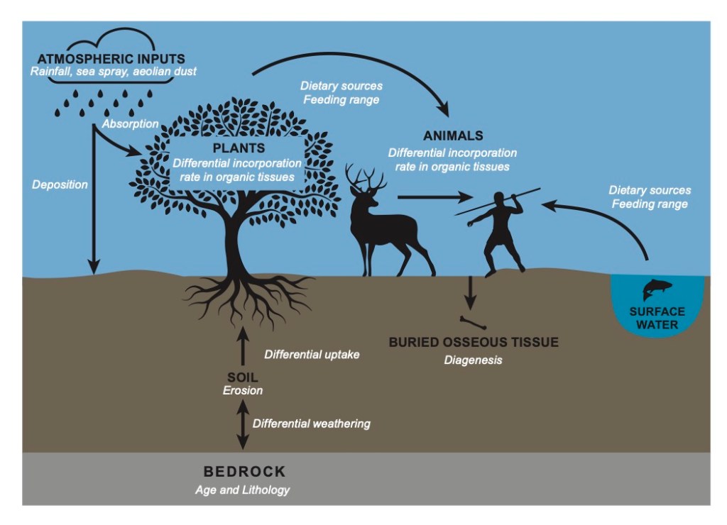
All isotope analysis of biological materials works by exploiting the fundamental fact of the food chain. The food, water, and even air that animals and plants consume have chemical links to their environmental conditions. For example, in the radiocarbon analysis of plants, the carbon isotopes reflect the composition of the air when the plant was alive, and the slow breakdown of these isotopes after the plant has died allows for the plant to be dated. In oxygen analysis, factors like altitude and precipitation patterns affect local hydrological cycles, leading to different ratios of oxygen isotopes in drinking water.
Strontium analysis relies on the way the chemicals in soil and water derive from bedrock. Strontium has similar properties to calcium, so it can be substituted for calcium when living organisms build tissues like bone and tooth enamel. Strontium in bedrock is released when the bedrock weathers into soil, or it can get leached into the water that flows through or around the bedrock. The strontium then enters the food chain as plants draw nutrients from the soil and water where they grow, and it gets incorporated into human and animal tissues as they eat the plants and the animals that have been feeding on the plants.
Figure 1 from Holt et al. 2021
Strontium analysis wouldn’t work if all the strontium in all the bedrocks were the same, but helpfully it isn’t. Bedrocks have different ratios of strontium isotopes in them. Chemically, isotopes are atoms of an element that have the same number of protons but different numbers of neutrons. As an analogy, you can think of elements as ice cream and isotopes as their different flavors. Mint chocolate chip and butter pecan are both ice cream, but if I gave you a bowl with three scoops of mint chocolate chip and one of butter pecan, you’d have no trouble telling how much of each flavor was in the bowl. The element strontium has four flavors (isotopes) that occur commonly in bedrocks. Archaeologists can separate the strontium from a sample, and by looking at how much there is of one flavor (the 87Sr isotope) versus another flavor (the 86Sr isotope), archaeologists can describe the nature of the strontium in an area – its 87/86 strontium ratio.
Understanding a place’s strontium ratio lets archaeologists think about whether various organic tissues could come from that area. All kinds of tissues can potentially be used for strontium analysis, but the most common are bone and tooth enamel. Tooth enamel is particularly useful because it’s resistant to absorbing more strontium from the soil where it was buried – which could mess up the results of the strontium analysis – and because it forms when an individual is a juvenile. This means it can be very helpful for identifying when a person grew up in a different place from the one where they were buried, which is great for archaeologists who want to understand issues like migration, nomadism, and trade networks in the past.
Strontium analysis does have limitations. Similar strontium ratios can be found in many geographical regions, so strontium analysis is better at identifying where a person was not from than it is for pinpointing where they were from. Because strontium analysis works by excluding possible places of origin, it’s most useful when applied alongside other isotope analyses that can exclude additional places of origin. Another challenge of strontium analysis is that it can be difficult to understand whether the strontium ratio of soils in the present is an accurate reflection of the strontium ratios of the past. Modern fertilizers and other soil treatments can affect strontium ratios, so archaeologists have to be careful in using modern comparisons for ancient individuals.
Properly applied*, however, strontium analysis can be a powerful tool for addressing many of the enduring questions we have about the past, such as understanding the nature of ancient diasporas or reconstructing pre-modern globalism. I look forward to many more studies like the fascinating examples cited above.
* A summary of Holt, Evans, and Madgwick. 2021. Strontium (87Sr/86Sr) mapping: A critical review of methods and approaches. Earth-Science Reviews 216: 103593.
This project has received funding from the European Union’s Horizon 2020 research and innovation programme under grant agreement No 839517.
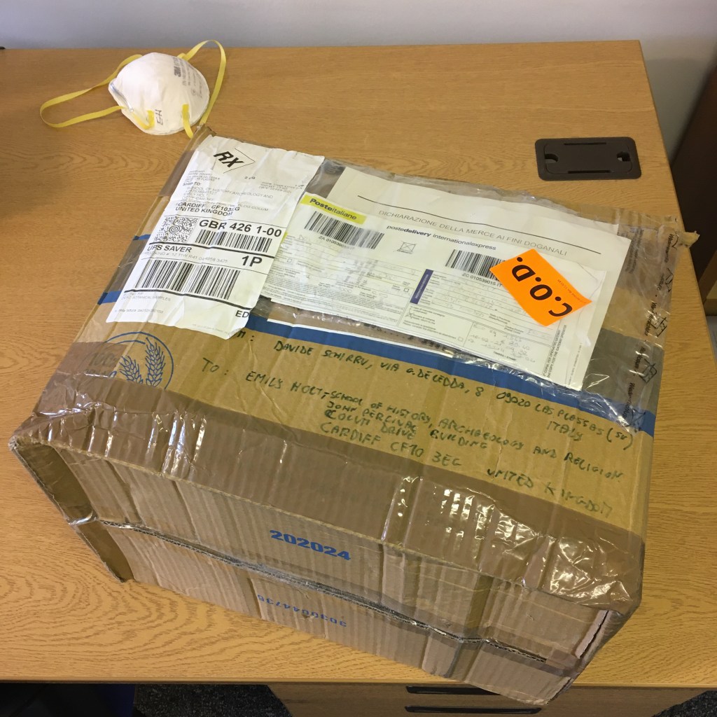
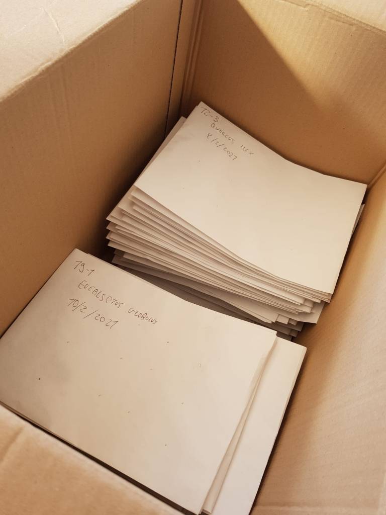
The long-awaited box – a little the worse for wear, but the samples inside are intact
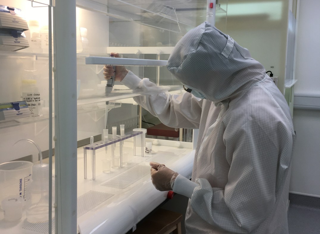
It took longer than expected, but the first batch of plant samples is finally here! They had an arduous journey if the state of the box is anything to judge by, but the samples themselves are in good shape and they don’t show signs of mold. I can start the preparatory processing right away, and I should have them ready for chemical processing by the end of next week.
The first steps in processing the samples are physical. The samples need to be frozen for a few hours and then freeze-dried for a couple of days. Each point on the map is represented by a set of three samples, so once the samples in each set are freeze-dried, they’ll be ground up and mixed together to create one homogenized sample. The homogenized samples will then be processed chemically before they’re analyzed for strontium.
Twelve sets of samples are already in the freezer and will be moved to the freeze dryer by the end of the day. Exciting progress!
Samples going into the freezer
This project has received funding from the European Union’s Horizon 2020 research and innovation programme under grant agreement No 839517.
Grandi notizie per ZANBA: il primo lotto di campioni botanici per la mappatura isotopica della Sardegna centrale è in viaggio per Cardiff! Davide ha iniziato nel migliore dei modi il lavoro sul campo, avendo già raccolto i campioni da31 dei 137 punti totali.
Ciascuno dei 137 punti si trova all’interno di una particolare zona litologica, con le zone più grandi rappresentate da un numero maggiore di punti. Il campionamento consiste nel prelevare foglie da alberi e alti arbusti: questi campioni devono, quando possibile, provenire da tre specie diverse situate entro un raggio di 500 metri intorno ad ogni punto. Il prelievo di tre campioni per punto ci consente di eseguire un campionamento omogeneizzato: in questo tipo di campionamento, le foglie dei tre campioni vengono liofilizzate, macinate e accuratamente miscelate per creare un campione di laboratorio tale da rappresentare la variabilità nell’area intorno a ciascun punto. Il campionamento omogeneizzato ci aiuta inoltre a creare un isoscape più rappresentativo, che risulti quindi meno influenzato da eventuali anomalie relative ad uno dei campioni.
I campioni dovrebbero arrivare la prossima settimana: non vedo l’ora di entrare in laboratorio per iniziare a trattarli!
This project has received funding from the European Union’s Horizon 2020 research and innovation programme under grant agreement No 839517.
Great news for ZANBA – the first batch of botanical samples for isotope mapping central Sardinia is on its way to Cardiff! Davide has done an impressive job with the fieldwork, already collecting material for 31 of the 137 total points to be sampled.
Each of the 137 points is inside a particular lithological zone, with larger zones being represented by greater numbers of points. When Davide samples, he takes leaves from trees and large bushes: three different plants representing three different species (when possible) located within a 500 meter radius of each point. Taking multiple samples per point allows us to do homogenized sampling. In homogenized sampling, the leaves from the three samples will be freeze-dried, ground up, and carefully mixed to create a laboratory sample that captures the variability in the area around each point. Homogenized sampling helps us create a more representative isoscape – one that’s less negatively affected if any of the plants Davide samples happen to be outliers.
The samples should arrive sometime next week, and I can’t wait to get into the lab to start processing them!
This project has received funding from the European Union’s Horizon 2020 research and innovation programme under grant agreement No 839517.
Davide nel corridoio principale del nuraghe arcaico Seneghe di Suni, Sardegna.
È stata dura far decollare il progetto ZANBA nel bel mezzo di una pandemia, ma sono lieta di annunciare che le cose si stanno finalmente muovendo. È particolarmente emozionante accogliere nella squadra l’archeologo sardo Davide Schirru! La ricerca di Davide si è sinora svolta nell’area dello studio: questa vicinanza gli darà l’opportunità di raccogliere campioni vegetali provenienti da tutta la Sardegna centrale. Davide mi invierà questi campioni all’Università di Cardiff, dove li preparerò e analizzerò per studiarne i rapporti isotopici dello stronzio. Ancora una volta, l’importanza di un networkdi rapporti consolidato è dimostrata dalla sua capacità di rimuovere ostacoli e allo stesso tempo sostenere la nostra resilienza!
La precedente ricerca di Davide si è concentrata sull’archeologia del paesaggio di Sardegna nell’età del Bronzo. L’ottimo stato di conservazione dei paesaggi preistorici della Sardegna offre un’opportunità eccezionale per indagarne i sistemi insediativi e per condurre uno studio approfondito del rapporto uomo-ambiente. Davide è particolarmente interessato allo sviluppo di analisi in ambiente GIS (Geographical Information Systems, Sistemi Informativi Territoriali), così come di analisi statistiche e quantitative delle proprietà spaziali dei paesaggi archeologici, portandolo a sviluppare un parallelo interesse nei linguaggi di scripting e programmazione. Davide sta attualmente completando il suo dottorato di ricerca in archeologia preistorica presso l’Università La Sapienza di Roma.
This project has received funding from the European Union’s Horizon 2020 research and innovation programme under grant agreement No 839517.
Davide Schirru inside the main corridor of the early nuraghe Seneghe in Suni, Sardinia.
It’s been tough getting ZANBA off the ground in the middle of a pandemic, but I’m delighted to announce that things are finally moving. It’s especially exciting to welcome Sardinian archaeologist Davide Schirru to the team! Davide’s ongoing research is based in the ZANBA study area, giving him the opportunity to collect plants from across the landscape of central Sardinia. Davide will send these plant samples to Cardiff University, where I will process them and analyze their strontium isotope ratios. Let’s hear it for the incredible power of networks to overcome obstacles and promote resilience!
Davide’s previous research has focused on landscape archaeology in Bronze Age Sardinia. The well-preserved prehistoric landscapes of Sardinia provide an exceptional opportunity to explore settlement systems and conduct a thorough study of the human-environment relationship. Davide is particularly interested in the development of GIS (Geographical Information Systems), statistical, and quantitative analyses of the spatial properties of archaeological landscapes, leading him to develop further interests in scripting and programming languages. Davide is currently completing his PhD in prehistoric archaeology at La Sapienza University of Rome.
This project has received funding from the European Union’s Horizon 2020 research and innovation programme under grant agreement No 839517.
In my last post, I highlighted archaeological research that showed that strong communities – local-level groups that worked together and maintained social ties – helped past societies weather major disruptions, delivering better outcomes for human health and prosperity and even helping sustain institutions above the local level. These are promising results for us, pointing to at least one practical way we can combat the effects of the pandemic. Working to support and maintain our communities now will help us come out of this pandemic in the strongest way we can. But the researchers’ conclusions also raise an obvious question – what are local communities doing or providing that contributes to their larger societies being resilient to a crisis?
There are dozens of books on resiliency from the past decade alone, but most focus on recent societies and institutions. Resiliency is a popular topic in archaeology as well, but many studies of resilience in the past focus on just one culture or time period. Here I will highlight an excellent cross-cultural study by Peter N. Peregrine, an anthropologist and archaeologist at Lawrence University. Peregrine examined 33 archaeologically known societies that weathered 22 environmental crises to test two hypotheses: did either local participation in decision-making or rigid social norms help human societies weather environmental crises? These two strategies have both been identified as sources of resilience in contemporary societies, but archaeology can test their utility in a broader range of cases. Again, the strength of Peregrine’s study is that it analyzes completely unrelated societies across large spans of time and space. As Peregrine puts it: “If a predictor of social resilience to climate-related disasters can be identified and applies to societies of varying scales and complexities throughout human history, then there is good reason to believe that it can be used to create interventions applicable today.”
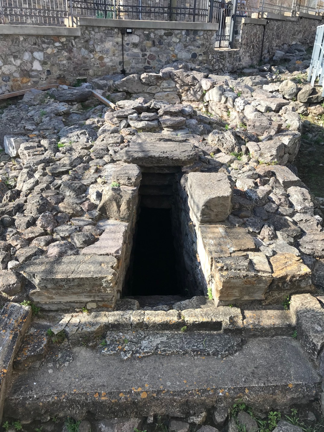
Inside the water temple of S. Anastasia in Sardara, Sardinia – a site of communal ritual for the Bronze Age Nuragic Culture
Peregrine trained research assistants to code ancient societies that faced severe environmental crises according to where they fell on scales of “corporate-exclusionary” (level of participation in decision making) and “looseness-tightness” (enforcement of social norms). They also coded how resilient the societies were by evaluating seven variables – population, health and nutrition, conflict, household organization, village organization, regional organization, and communal ritual – both before and after the environmental crises occurred. You’ll notice how many of these variables are similar to those used by the LTVTP-NABO collaboration I highlighted in the previous post, reflecting the basic kinds of human well-being we hope to be able to maintain even in crisis situations.
Peregrine found a positive relationship between resilience to environmental crisis and high levels of participation in decision making*. When leadership was more fluid and open to input and action at local levels, societies were more resilient, maintaining higher levels of well-being throughout the crisis. Peregrine found the opposite for enforcement of social norms, however; societies with strict enforcement of social norms were less resilient to environmental crisis. For the diversity of cultures and over the long time scales studied by Peregrine, rigid codes of behavior were detrimental.
A pandemic doesn’t pose the same challenges as an environmental crisis, but the importance of Peregrine’s findings is still apparent. One factor in creating resilience is broad participation in local decision making and a willingness on the part of higher levels of government to listen to local voices. It makes sense that local people are the often the first to recognize how a crisis is affecting their particular community and that they are likely to have useful ideas for how the crisis needs to be handled to maintain well-being in their area. The current pandemic poses unprecedented hurdles for average citizens trying to participate in governance, but it is essential that we find ways. Making local decisions based on local input is key to maintaining our well-being.
* I prefer to feature open access research so everyone can read and evaluate the work for themselves, but if you happen to have access to academic journals, I recommend the following archaeological and historical study. It reaches conclusions similar to Peregrine’s regarding the role of local-level knowledge and participation in decision making for achieving sustainable soil use in case studies of ancient Mediterranean agriculture.
Butzer, K (2005) Environmental history in the Mediterranean world: cross-disciplinary investigation of cause-and-effect for degradation and soil erosion. Journal of Archaeological Science 32: 1773-1800.
This project has received funding from the European Union’s Horizon 2020 research and innovation programme under grant agreement No 839517.
Last week, I argued that archaeology has something useful to say in this time of Coronavirus. This may seem like a bold assertion, even to other academics. I wonder how many of my colleagues in economics, sociology, and psychology see archaeology as a social science like their own disciplines. I wonder how many people in general look at today’s problems – be they Coronavirus or climate change – and think “let’s ask the archaeologists.”
I’ll be the first to admit that my argument needs to be supported by evidence before anyone should take it seriously. So that’s what I intend to do: provide evidence that the broad human past gives us valuable insight into what we can and should do now. I’ll focus on open access studies that anyone can read, and I encourage everyone to read the originals and assess for yourselves whether these are good evidence for the contemporary relevance of archaeological insight.
My first piece of evidence is an article* by Michelle Hegmon and Matthew Peeples on behalf of the LTVTP-NABO collaboration. The Long- Term Vulnerability and Transformation Project (LTVTP) focuses on archaeological cases of social transformation in the arid and semi-arid United States Southwest and northern Mexico. The North Atlantic Biocultural Organization (NABO) focuses on cases that took place in the subarctic and arctic North Atlantic. Together, the LTVTP-NABO collaboration examined 18 examples of major social transformations as varied as the end of the Norse occupation of Greenland and the depopulation of the Mesa Verde region. The geographical, environmental, chronological, and cultural diversity of the cases studied suggests that any strong patterns probably hold true for human societies generally: that is, they point to specific ways that all human societies tend to respond to stress.
The researchers coded a broad set of variables, from institutional breakdown and depopulation to human securities**, migration, household organization, and changes in material culture (the archaeological catch-all term for “stuff”). The researchers then performed correspondence analyses among these different variables to identify meaningful relationships.
Figure 3 from the cited article showing correspondence analysis of all human securities variables. Red and yellow cases have higher levels of breakdown.
Their results are fascinating and the paper is worth a detailed read, but some of their conclusions feel particularly relevant in the current crisis. First, there is a strong relationship between the breakdown of institutions and a decline in human securities. No one is an island: nobody thrives when we let our sustaining institutions crumble. How we get food, how we receive medical care, and how we keep interpersonal violence in check are all embedded in institutional systems. If those systems fail, we’re likely to suffer. We’re witnessing severe stresses on some of our systems right now as they struggle to keep up with the demands created by the current pandemic.
The hopeful part of the study is that the researchers identified communities and community security as strong predictors that social transformation would be less painful. If communities remained strong – if they didn’t disintegrate under the weight of social transformations – people experienced less food insecurity, less interpersonal violence, and less death. The researchers also found a positive feedback loop – strong communities could bolster institutional security, preventing or dampening the major institutional collapses that were found to be disastrous in the less fortunate cases. The authors conclude: “We must consider the people’s experiences because what happens at the local level can stabilize society, can augment people’s capabilities for contributing in positive ways, and thus can help avert disaster.”
I’m probably not the only one who’s found herself reaching out to friends she hasn’t talked to in years to check on how they’re doing in this crazy situation. It turns out this normal human impulse may have a practical benefit. Cross-cultural, cross-temporal evidence reminds us that our communities make us resilient. Strong communities protect and provide and care for us when larger institutions falter and can even prop up those institutions until they recover their footing. Community-building in the time of Coronavirus may not look like it used to, but it’s one of the smartest things we can do.
* Hegmon M, Peeples MA, on behalf of the LTVTP-NABO collaboration (2018) The human experience of social transformation: Insights from comparative archaeology. PLoS ONE 13(11): e0208060. https://doi.org/10.1371/journal.pone.0208060
** The researchers followed the United Nations definition of seven types of human securities to assess human security broadly: economic, food, health, environmental, personal, community, political.
This project has received funding from the European Union’s Horizon 2020 research and innovation programme under grant agreement No 839517.